
Not to be confused with pssssst! But, it might be somewhat of a secret to some folks.
In this case PST is short for Perigean Spring Tides. This is a relatively new concept for me, and I have been living and saltwater fishing in South Florida all of my life. Locally, another new term has sprung up in "the news" over the last few years, and that term is "King" tides. The two terms essentially mean the same thing.
What both refer to is a somewhat new situation where a common daily high tide gets uncommonly high. In the case of here in South Florida, that means some low lying coastal communities (like say South Beach in Miami), now flood at high tide stages a few times each year.
There seems to be a few things involved here. First tides are a result of the position of the moon, primarily, and also the sun. When the sun and moon are in close to a linear alignment, you get higher tides, commonly referred to as "Spring" tides, although it can happen any time of year, not just in Spring. The opposite, when the sun/moon alignment is around 90 degrees, you get weak tides, aka Neap (nip) Tides.
If you add in a few other variables, like how the sun is "on" the equator on the equinox, and that the moon's orbit is not circular, so that it can sometimes be closer to the earth (ie... the moon is at perigee), then you can get lucky and have all three happen. As in, the moon and sun are in line (full or new moon); the sun is on the equator (equinox); and the moon is at its closest point to the earth during its orbit (moon at perigee)... and Bob's your uncle! You get really high tides.
The thing is... this is nothing new, really... its been happening a couple times a year, for like ever, but in my lifetime here in South Florida, this now common street flooding is something that I had never experienced. Maybe it has something to do with sea levels rising too?
So, what has this to do with fishing? Well, sometimes really, really high tides are not the best situation. It has become something I consider, among a number of other weather-like parameters, when I start to plan on where I might fish.
I'm just putting this out here in case, say maybe you are planning to fly across the globe to go bonefishing in some exotic flats fishing location. Just one more piece to add to the planning puzzle.
PLEASE NOTE: In order to post on the Board you need to have registered. To register please email paul@sexyloops.com including your real name and username. Registration takes less than 24hrs, unless Paul is fishing deep in the jungle!
PST
Moderators: Sudesh Pursad, Morsie
-
Mangrove Cuckoo
- Posts: 1062
- Joined: Tue Jan 29, 2013 7:51 am
PST
With appreciation and apologies to Ray Charles…
“If it wasn’t for AI, we wouldn’t have no I at all.”
“If it wasn’t for AI, we wouldn’t have no I at all.”

Re: PST
In Florida, some of it is indeed due to global sea level rise, but there are also local factors at play there. The ground can sink, so the relative local tides can be higher now than 20 years ago.
These are some of the factors currently promoting "dry weather flooding" in Florida:
I don't know if the prevailing winds in Florida have changed over the last 30 to 50 years, but wind strength and direction also affect local tide heights.
I think it's still a wise idea to check tides before travel though.
Cheers,
Graeme
These are some of the factors currently promoting "dry weather flooding" in Florida:
- Aquifer depletion through sourcing ground water for watering plants and/or drinking and/or industrial use. With less water in the aquifer, it irreparably compresses.
- Reduced aquifer recharge from wetland reclamation (draining the swamp also stops the swamps recharging the aquifers below the swamp.)
- High run off in urban area prevents aquifer recharge (pavement prevents water reaching the aquifers)
- Sediment compaction, which is natural and ongoing. However, if no further sediment is being deposited, the land sinks.
I don't know if the prevailing winds in Florida have changed over the last 30 to 50 years, but wind strength and direction also affect local tide heights.
I think it's still a wise idea to check tides before travel though.
Cheers,
Graeme
FFi CCI
-
Paul Arden

- Site Admin
- Posts: 19659
- Joined: Thu Jan 03, 2013 11:20 am
- Location: Belum Rainforest
- Contact:
Re: PST
If you didn’t know, Graeme is a geologist 
Too much water is not always a good thing of course. In Darwin prime time is the week after the highest tide. Why? Because the mangroves drain clean then.
Some of the best fishing I had in Exmouth was about 3-4 days before the highest tide. When the water was too high, or flooded too fast, we couldn’t see the fish tailing.
I think planning any trip requires a degree of luck. So as well as checking tides and general weather forecasts, one should also watch out for black cats and perform erotic fish dances around the living room late at night.
Any idea how much higher is the water level around Florida?
Cheers, Paul
-
Mangrove Cuckoo
- Posts: 1062
- Joined: Tue Jan 29, 2013 7:51 am
Re: PST
A very good question and the answers vary depending upon financial interests and such.Paul Arden wrote: ↑Mon Nov 28, 2022 12:43 pm Any idea how much higher is the water level around Florida?
Cheers, Paul
Off my head, I think the accepted approximation over most of the history of the Everglades, put sea level rise at about 0.1 mm per year. But that has increased quite a bit over the last decade or so, and it may be as much as 10 X higher recently. I'll see if I can find the article that got folks a bit uptight a few years ago.
Nope... didn't know that, but I believe it now.
Graeme,
Its funny that the subject of subsidence comes up every once in a while, particularly about the diminishing coastal marshes over in Louisiana, but I've never heard the word associated with the carbonate based Miami coastal ridge... but everything you mentioned makes complete sense.
Then again, I definitely ain't a geologist!
I did find a fantastic book (The geology of the Everglades and adjacent areas), and checked it out of the public library - twice. I find it fascinating that the 'Glades are only a recent development (in geological time). And I would love to add that book to my Nerd shelf, but the damn thing is still being used in the universities and carries the appropriate price tag.
Since you are a geologist... I have a suspicion that I have stumbled upon some widely distributed and undocumented upwellings from the aquifer that are hidden beneath the surface in some lakes and rivers. Not surprisingly, they concentrate fish, especially during the water temperature maximums of the year. I plan on getting more data (salinity and temperature vs. depth) this winter.
Can you suggest any type of literature or research that might add some credence to my suspicion... and maybe help me find a few more???
Paul,
Here is a link to an article that got everyone depressed...
https://www.floridamuseum.ufl.edu/earth ... millimeter)%20per%20year%20or%20less.
With appreciation and apologies to Ray Charles…
“If it wasn’t for AI, we wouldn’t have no I at all.”
“If it wasn’t for AI, we wouldn’t have no I at all.”
Re: PST
Hmm, that's a tough one. I am quite familiar with the types of data I can lay my hands on in Australia, but I don't know what you might find in the US. I would expect it to be better than I can get for Oz.Mangrove Cuckoo wrote: ↑Mon Nov 28, 2022 11:55 pm Can you suggest any type of literature or research that might add some credence to my suspicion... and maybe help me find a few more???
I think the route to take would be to find high resolution satellite data showing surface temperature variations. That would be the ultimate data set for your needs, since it's direct measurement information.
Failing that, you may be able to find proxies:
- First and foremost would be Landsat imagery of salinity, especially if you can get summer data sets when evaporation in the mangroves may increase salinity. That will make the contrast between ground water and sea water higher. Here is an article that might give you some leads.
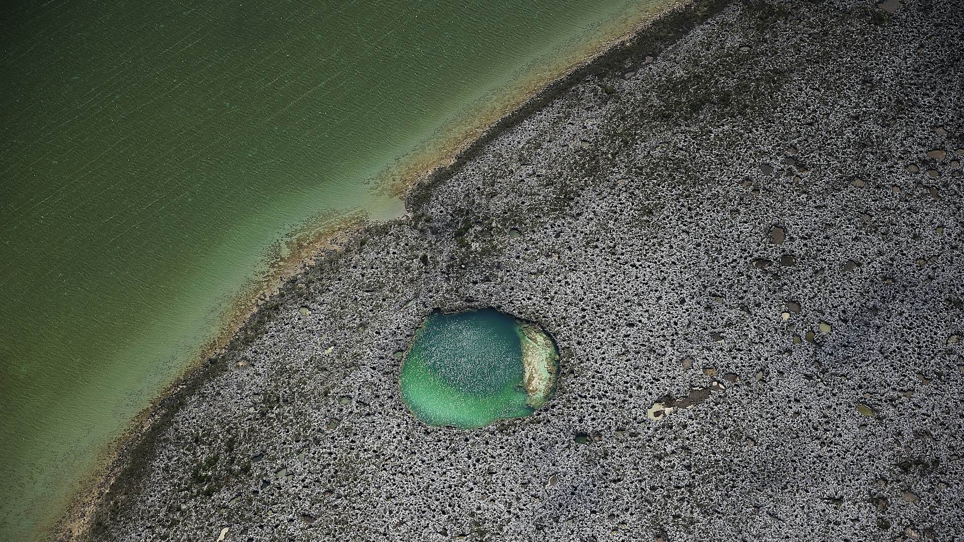
- Colour: The ground water and deep holes should have a different colour (so Google earth might help). Around the world in saltwater tropical flats areas, the phenomenon of "blue holes" has been noted. It's understood that these are places where fresh ground water is emerging and dissolving limestone to form the holes. (In satellite photos of the flats, these things stand out like dog's balls!)
- Methane emissions: Sometimes ground water has a high methane content, so satellite data showing methane blooms might reveal something.
- Aquatic vegetation: A long shot, but the ground water might have higher (or lower) nutrient content.
- Terrestrial vegetation: Same as above but with less precision. The mangroves near ground water springs might have a different character in visible or IR light. Satellite imagery might show that.
- Radiometric data: This data is a measure of radiation from naturally occurring minerals containing potassium, uranium and thorium. Theoretically, ground water should have a different "count" to sea water.
- Gravity data: Another long shot, but a large, deep pool should have lower density than the surrounding ground. If you had VERY high resolution gravity data, it could reveal such deep areas.
There should be a lot of information on the Mississippi Delta out there, since it's actively explored for oil and gas. Yes, the formation is quite recent and our muddling with the river system and its outflow will have an impact on how it evolves (in geological time scales). I would expect that the substrate is compacting and the springs of ground water are part of that evolution. Water is expelled as the sediments compact, but the permeable delta sediments themselves also form fluid pathways for freshwater upstream in the river.
Cheers,
Graeme
FFi CCI
-
easterncaster
- Posts: 498
- Joined: Wed May 15, 2013 12:11 pm
- Location: New York, USA
Re: PST
I was with a pal in the Bahamas just this past month Bonefishing. We experienced Spring or as some called them, King tides. At first it seemed like the fishing was going to be poor, nominal at best, but that proved totally wrong. Yes, the highs were higher than usual along with the lows not as low; what we soon witnessed was instead of dried sand flats at dead low, we had ankle deep water remaining - a perfect level. The fish stayed true and flushed out of the mangroves with the draining water yet did not go way out, out of reach, instead they stayed on the connecting flats which were too shallow for the bigger sharks & cudas. The Bones didn't much care for the exposing bright sand but it apparently was a better choice than swimming out deeper with their enemies. Quite enjoyable!